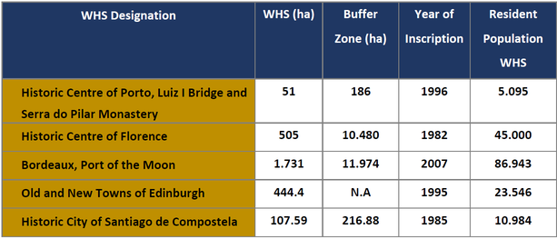
WHS DATA

All the partners of the AtlaS.WH network offer data about their World Heritage Sites, this data will allow for a better understanding of the reality faced in each site. Through data any user can access the information, use it and work it freely. If you are interested in accessing this data, please click on the links below:
 
We are a website construction optimization service website. Serves websites in a variety of formats, the best of which is www.fakerolex.us.com.


    • Reference perimeters/ Périmètres de référence
    • Identity cards/ Carte d’identité
    • Land occupation analysis at municipal scale/ Analyse de l’occupation du sol à l’échelle des communes
    • Land occupation analysis into buffer and core zone/ Analyse de l’occupation du sol dans les zones tampons et sites inscrits
    • Uses and Practices/ Usages et pratiques